
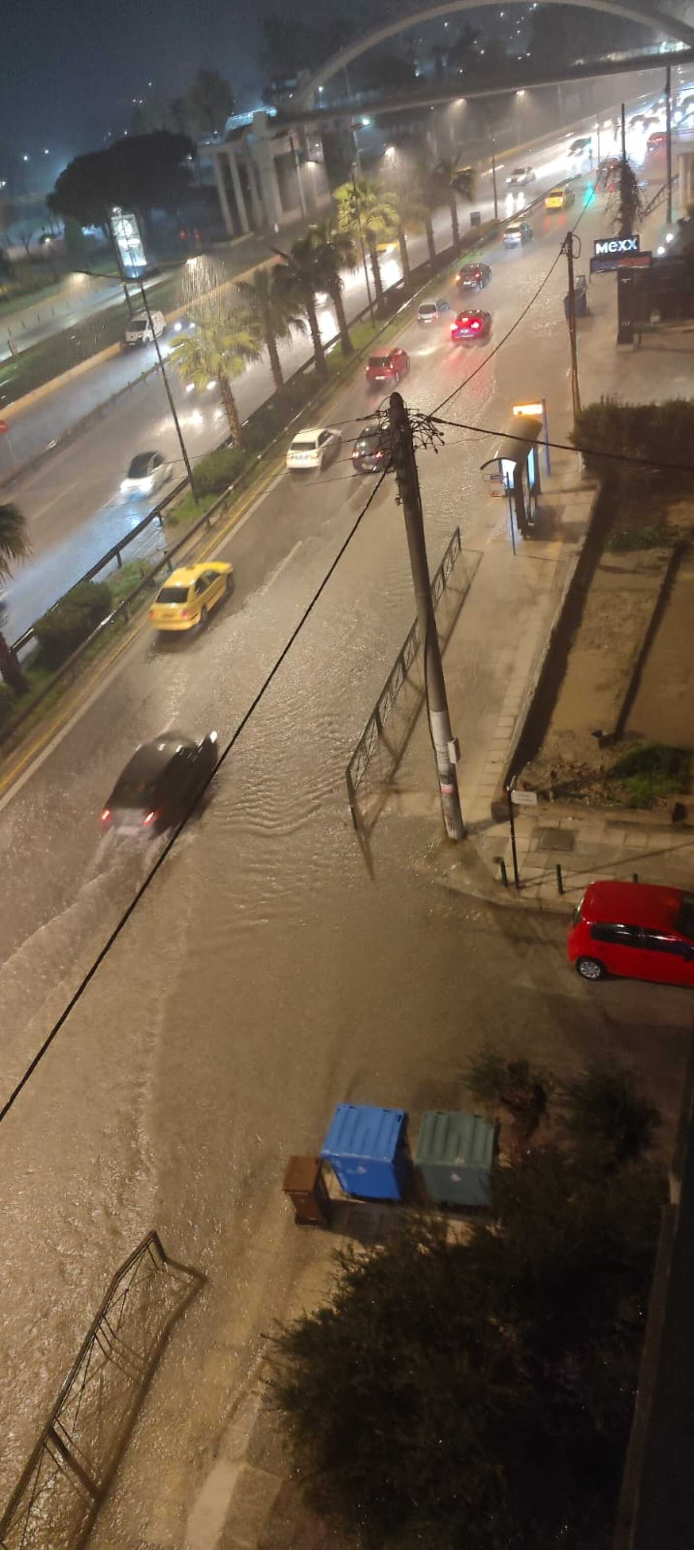
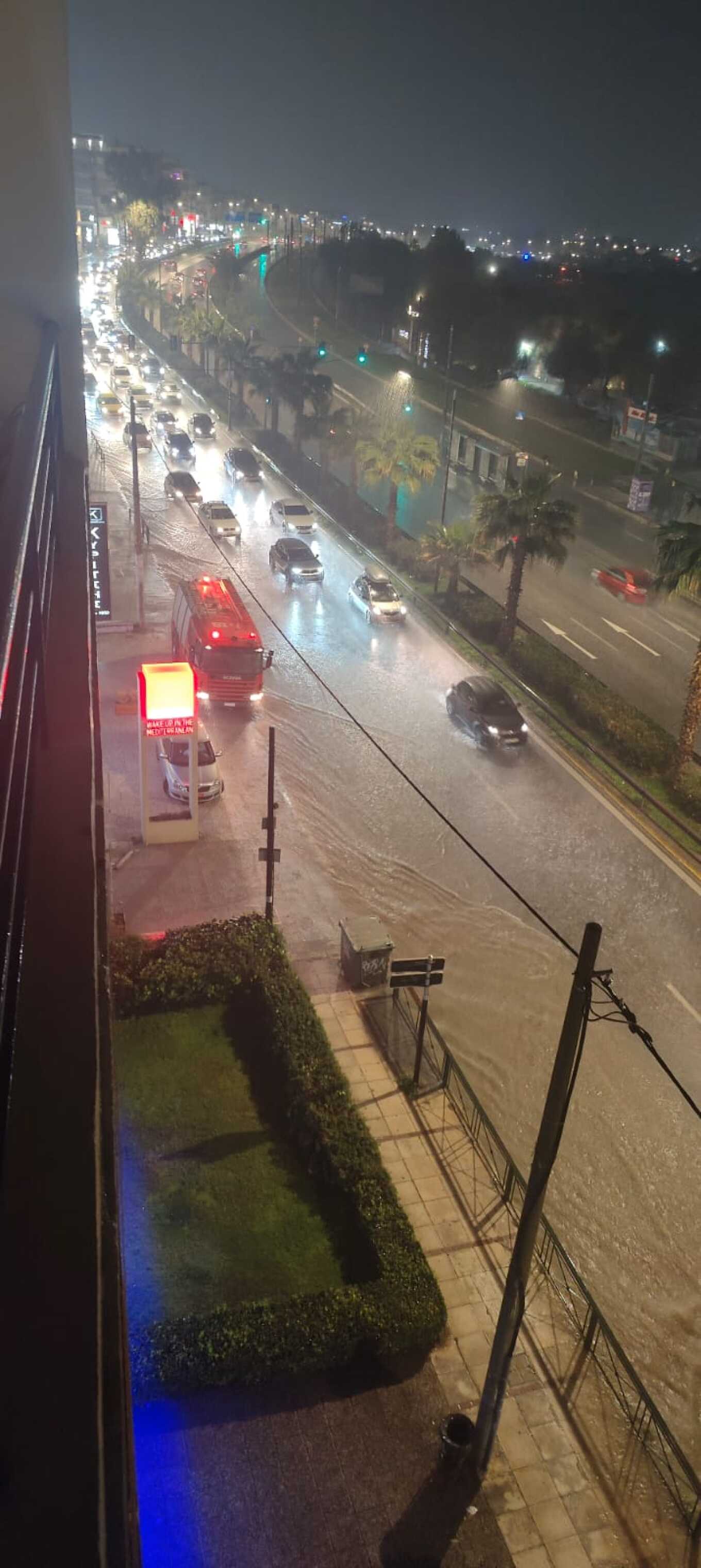
The weather has worsened since yesterday, with heavy rains and thunderstorms causing significant problems in Attica, Evia, and Zakynthos. The emergency bulletin from the National Meteorological Service (EMY) remains in effect today, as gale-force winds are expected in the east, and temperatures will drop significantly.
More specifically:
- Localized heavy rain and thunderstorms are expected:
- Until Tuesday morning (04-02-2025) in eastern Central Greece (including Attica), Evia, eastern Thessaly, and the Sporades.
- From late Tuesday morning (04-02-2025) in the Cyclades and the Eastern Aegean islands.
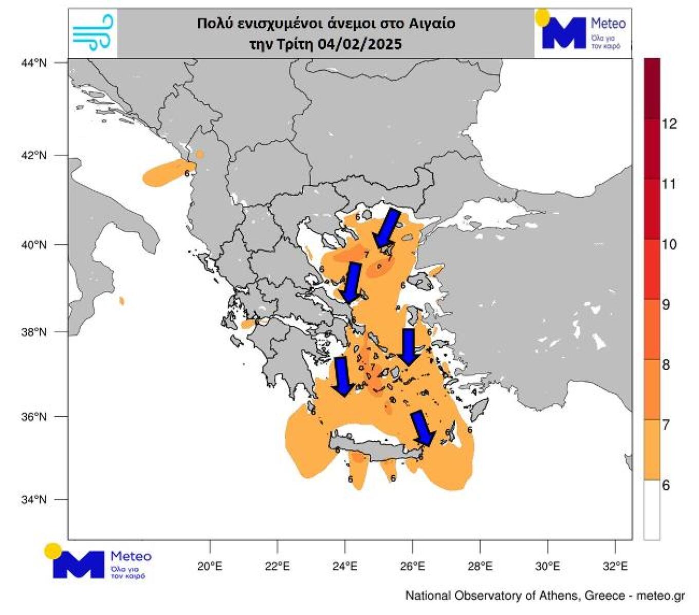
- Locally gale-force northeasterly winds are forecasted for Tuesday (04-02-2025) from early morning until the afternoon in Thrace, the northeastern Aegean islands, the Sporades, and temporarily in eastern Thessaly and Evia.
- From Wednesday through Friday, gale-force north-northeasterly winds will persist in the Aegean.
- Temperature drop:
- On Tuesday (04-02-2025), temperatures will drop by 6-7°C in the north, and on Wednesday (05-02-2025), they will decrease further across the country.
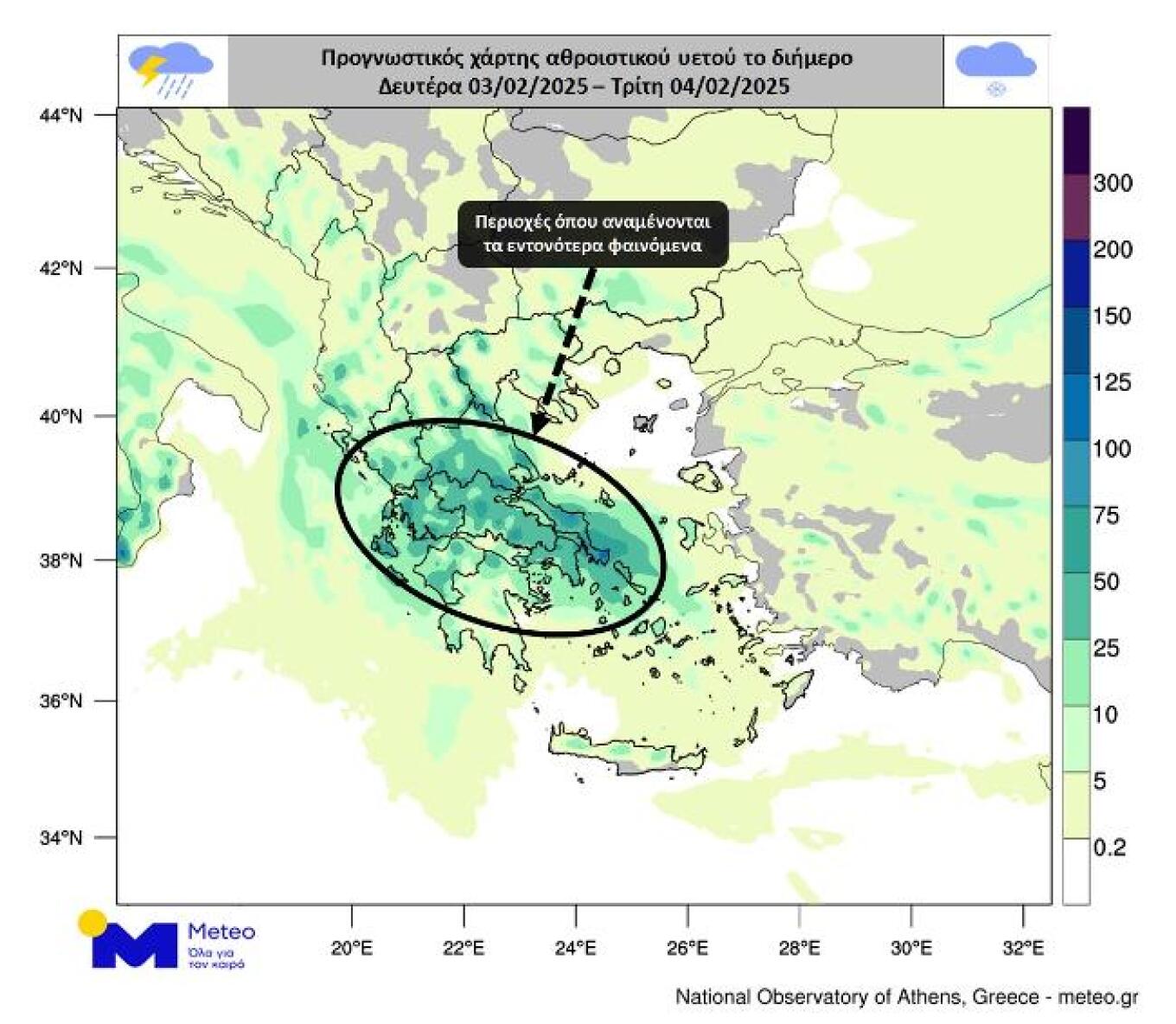
According to Meteo, snowfall is expected in the mountainous mainland and temporarily in lower-altitude areas of Western Macedonia. The most intense weather phenomena will occur in eastern and southern mainland Greece, Evia, and the Cyclades, while conditions will quickly improve in Western Greece and gradually in Northern Greece.
The following forecast maps depict the estimated cumulative precipitation (rain/snow) until Tuesday night, 04/02, and the estimated maximum wind intensities for Tuesday, 04/02.
Severe Weather Retreating in Attica
According to meteorologist Theodoros Kolydas, the most intense weather phenomena in Attica are receding. Average rainfall levels reached 20-30mm, while in the southern areas, they neared 40mm, particularly around the Peace and Friendship Stadium (SEF).
“Most of the intense weather phenomena in Attica are gradually retreating. The average rainfall levels were 20-30mm, while locally in the south, they approached 40mm (at SEF).” #storm #rain
“Just a few light effects left in Attica.”
Meteorologist Giannis Tsatrafilias also warns of a significant temperature drop starting today, noting that the polar jet stream will bring prolonged cold.
Prolonged Cold Due to Polar Jet Stream
Good morning and have a great week!
The weather will have a wintery feel this week in Greece, as an air current approximately 10km above the Earth’s surface will favor the transport of cold air masses to our region. The cold spell is expected to persist at least until the beginning of next week.
Main Weather Characteristics for the Week:
- Significant temperature drop from tomorrow, gradually moving from north to south, reaching up to 12°C lower. The coldest day will be Thursday, 06/02, with temperatures in central Athens not exceeding 7-8°C.
- Persistent strong northerly winds in the eastern seas, blowing above 8 Beaufort from Tuesday, 04/02, throughout the week, making the cold feel even more intense.
- Snowfall will generally be light and mostly “decorative.” It will occur mainly in the mountainous mainland but could also reach lower altitudes (around 500 meters) on Wednesday and Thursday in the eastern windward regions, from Thessaly southward (including Attica, but without significant issues).
Issues Yesterday in Attica, Evia, and Zakynthos
Heavy rainfall hit parts of Attica and Evia yesterday, while in Zakynthos, roads were closed, and house courtyards were flooded.
- On Poseidonos Avenue in Alimos, a manhole cover was dislodged, spilling sewage onto the road.
According to Alimos Mayor Andreas Kondylis, who also shared a video of the incident:
“Once again, it’s raining, and once again, EYDAP (Athens Water and Sewerage Company) is releasing sewage onto Poseidonos… We are awaiting the construction of the new pipeline, which we have been promised will begin in 2025, to finally resolve this long-standing problem.”
Later, according to an update from the Municipality of Alimos, the sewage discharge had stopped, with the leaked quantity now being absorbed into the stormwater drainage system.
- The Fire Department and EYDAP were involved in addressing the issue, with EYDAP taking the lead in resolving it.
- Authorities, learning from past experiences, chose not to use heavy vehicles to avoid causing additional damage to the infrastructure.
The situation remains under control, with specialists continuing their assessment for a complete resolution of the problem.
The Weather Today
Rain will occur in many areas of the country. Thunderstorms are expected mainly in the east and south, where phenomena will be locally intense and may be accompanied by hail. Snow will fall in the mountainous mainland and, temporarily, in lower-altitude areas of Western Macedonia. Gradually, the weather will improve in Western and Northern Greece.
Temperatures will range from -4 to 4°C in Western Macedonia, from -1 to 9-10°C in the rest of northern Greece, from 5 to 15°C in the western and southern mainland, from 5 to 10-11°C in Thessaly, from 6 to 12°C in the rest of the eastern mainland, from 7 to 15°C in the Ionian Islands, from 5 to 10°C in the northern Aegean islands, and from 8 to 15-17°C in the rest of the Aegean islands and Crete.
In the northern Aegean, northeasterly winds will blow at 5-6 Beaufort, locally reaching 7 Beaufort. In the rest of the Aegean, northerly winds will prevail at 6-7 Beaufort, possibly reaching 8 Beaufort locally. In the Ionian, easterly winds will blow at 4-5 Beaufort, possibly reaching 6 Beaufort temporarily in some areas.
In Attica, rain and thunderstorms are expected, which may be temporarily strong and accompanied by hail. Snowfall will occur in the higher parts of Mount Parnitha. By midday, the phenomena will be limited to the northern parts of the region and will then cease. Winds will be from the north-northeast at 4-5 Beaufort, gradually shifting to northerly at 6 Beaufort. Temperatures will range from 7 to 12°C.
In Thessaloniki, periodic rain is expected, with weather improving in the morning. Winds will be from the north at 3-4 Beaufort. Temperatures will range from 5 to 9°C.
The Weather on Wednesday, 05-02-2025
In Thessaly, the Sporades, eastern Central Greece, Evia, the Cyclades, Crete, and temporarily in the morning in Central Macedonia and the Ionian, cloudy skies with local rain are forecast. In the rest of the country, there will be scattered clouds, temporarily increasing at times. Light snowfall will occur in the mountainous mainland, Evia, and Crete.
Winds will blow from the north, at 3-5 Beaufort in the west, 5-7 Beaufort in the east, and up to 8 Beaufort in the Aegean, possibly reaching 9 Beaufort in the southeast.
Temperatures will drop further, reaching lower-than-average levels for the season. In the north and east, they will not exceed 10-12°C, while in the west and island regions, they will reach 13-15°C. Frost will occur locally in central and northern mainland areas in the morning and evening hours.
The Weather on Thursday, 06-02-2025
In the eastern mainland, the Cyclades, and Crete, partly cloudy skies are expected, temporarily increasing with light local rain and weak snowfall in the mountainous areas of eastern Central Greece, Evia, the Peloponnese, and Crete. In the rest of the country, there will be scattered clouds, locally increasing in western Peloponnese.
Winds in the west will blow from the east at 3-5 Beaufort, gradually shifting to southerly with the same intensity. In the east, winds will be from the north at 6-7 Beaufort, reaching 8 Beaufort locally in the Aegean but weakening gradually from the north.
Temperatures will not see significant changes. Frost will occur in the mainland during the morning and evening hours.
The Weather on Friday, 07-02-2025
In the west, initially, there will be scattered clouds, gradually increasing, bringing local rain and possibly isolated thunderstorms in the northwest by night. In the rest of the country, temporarily increased clouds are expected. Light snowfall will occur in the central and northern mountainous areas.
Winds will blow from the south at 3-5 Beaufort in the west and from the north at 4-6 Beaufort in the east.
Temperatures will rise slightly, mainly in central and southern areas. Frost will occur in mainland areas in the morning and evening hours.
The Weather on Saturday, 08-02-2025
Throughout the country, partly cloudy skies are expected, occasionally increasing, with local rain in the eastern mainland, the Sporades, Evia, and the northeastern Aegean islands. Light snowfall will occur in the central and northern mountainous mainland.
Winds will be from the east-southeast in the west and from the north in the east, at 4-6 Beaufort, locally reaching 7 Beaufort in the Aegean.
Temperatures will remain stable. Frost will occur in mainland areas in the morning and evening hours.
Ask me anything
Explore related questions