With rainfall since the early morning hours, Attica is now part of the dangerous weather conditions expected to affect a large part of the country through Monday, according to the updated Forecast Bulletin of the Hellenic National Meteorological Service (HNMS/EMY).
The Peloponnese and Arcadia are already at the forefront of the first weather front, while a temporary lull is expected before a second wave develops late in the afternoon, accompanied by very strong wind gusts.
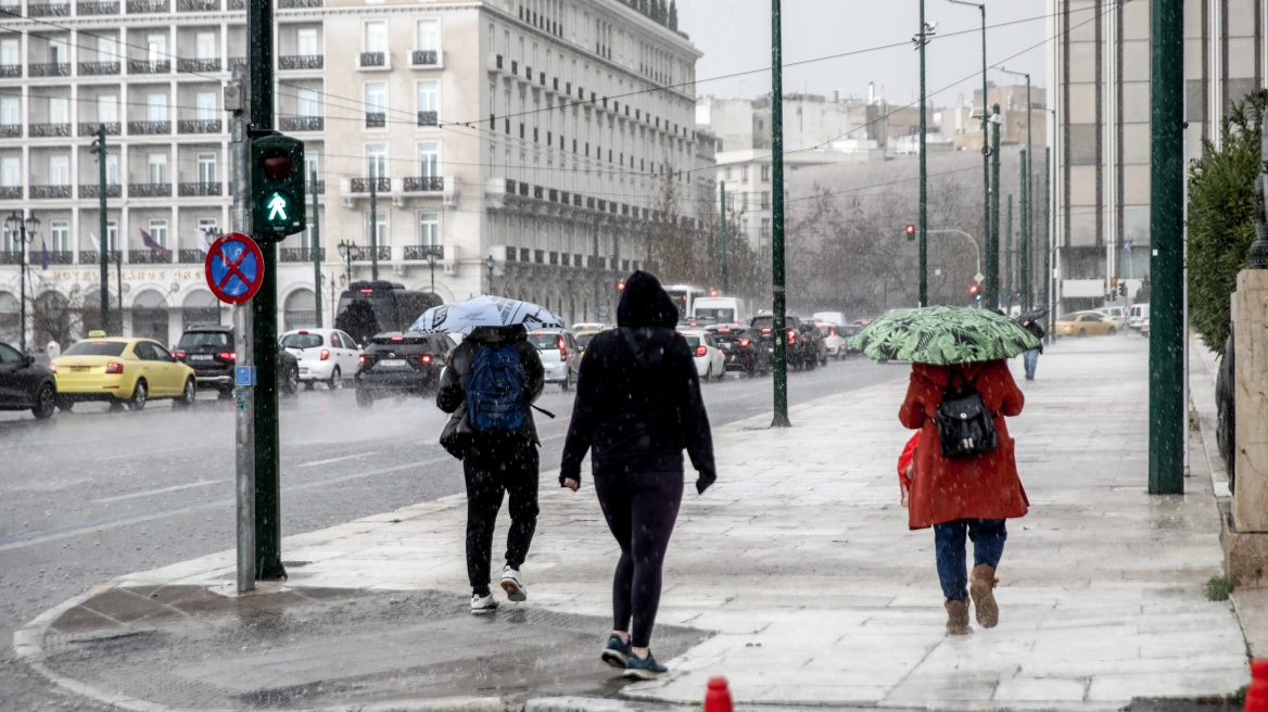
Heavy rain and thunderstorms in Attica
For Attica, two distinct phases of severe weather are forecast: from 06:00 to 10:00 in the morning, and again from afternoon to evening, with heavy rain and thunderstorms. According to data from Meteo, rainfall rates exceeding 3.6 mm per hour are already being recorded in Agia Paraskevi, Maroussi, and Malakasa, while 20 mm has been exceeded in Vilia and Oropos.
Seven regions on “red alert”
Under red warning (red code) are the Peloponnese, Thessaly, Central Macedonia, Pieria, Imathia, Halkidiki, and the Northern Aegean. In several areas, the phenomena will be accompanied by gale-force winds of 8 to 9 Beaufort, while localized hailstorms cannot be ruled out.
At the same time, an orange warning is in effect for the Ionian Islands, Crete, Epirus, Macedonia, and Central Greece, including Attica and Evia.
Category 4 heavy rainfall
The main characteristics of the severe weather system—which will initially affect western regions and then spread across the entire country—are locally heavy rain and thunderstorms, which in island and coastal areas may be accompanied by hail, snowfall in mountainous areas of central and northern mainland Greece, and locally in lowland areas of the northeastern regions, mainly Evros, from Sunday afternoon onward. Also expected are gale-force winds over the seas and a slight drop in temperature.
According to the Rainfall Episode Classification (RPI) applied by the Meteo unit of the National Observatory of Athens, the phenomenon is classified as Category 4 (Very Significant).
Detailed timing of the phenomena
In the Peloponnese, intense phenomena will last from the early hours of Sunday until late afternoon, under a red warning. In Thessaly and the regional units of Pieria, Imathia, and Halkidiki, the phenomena will occur from morning until late afternoon, also under a red warning. In the Eastern Aegean, deterioration is expected from midday hours.
An orange warning is in effect for the Ionian Islands—mainly Lefkada, Kefalonia, Ithaca, and Zakynthos—from the early hours of Sunday until late afternoon; for Crete (mainly western and southern parts) from the morning; for Epirus and western Central Greece until midday; for the remaining areas of Central Macedonia until the afternoon; and for eastern Central Greece, Attica, Evia, and the Dodecanese from midday onward.
A “rain” of 112 alerts
A state of heightened readiness was issued via 112 emergency alerts for the Regional Units of Achaia, Ilia, Messinia, Arcadia, Thessaly, Zakynthos, Kefalonia, and Crete, following an urgent notification from Civil Protection, with recommendations to limit travel and exercise increased caution.
Authorities are urging citizens to restrict their movements and strictly follow self-protection guidelines.
Due to the situation, the Risk Assessment Committee convened an emergency meeting under the Secretary General for Civil Protection, with the participation of the Minister for Climate Crisis and Civil Protection. The National Operations Coordination Center has already informed municipalities and regions, which have been instructed to remain in full operational readiness.
Citizens are advised to exercise increased caution, avoid unnecessary travel—especially in areas with a history of flooding or landslides—and to follow the instructions of Civil Protection authorities.
From the early hours of Monday, 02/02, the phenomena will be limited to Thrace, the eastern parts of the Aegean, and Crete, and will gradually weaken. Gradual easing of winds is also expected on Monday, 02/02.
Ask me anything
Explore related questions